Ancient Indian Rock Music

Usually neolithic rock art sites like
Bhimbetka,
Karabad,
Shamla Hill
, have images of  anthropomorphic figures performing
various activities. The rock art site at Kupgal village in Bellary, Karnataka,
has something more fascinating: dolerite boulders which emit musical tones
when struck by granite. The boulders found on top of hills, which were called
Peacock Hill by the British and Hiregudda (Big Hill) by the locals, have
grooves on them and only when those grooves are struck, music is produced.

The rock art tells us a bit about the people who created them. The most common
object depicted in their art is the Zebus or the the domesticated long horned
humped back Indian cattle. The cattle appear in various images, sometimes
alone, sometimes facing each other and sometimes being hunted by stick figures
with bows and arrows. In some images cattle are shown with three horns and
there is also a depiction of a ritual involving the burning of cow dung.

After cattle, the second most popular image is that of the anthropomorphic
ithyphallic figures, depicted having sex, using bows and arrows, raiding
cattle, riding animals and dancing. Besides this there are images of other
animals like elephants, tigers, deers and symbols like ladder and foot prints.

The location of some of the art is on difficult to reach rock formations
located at great heights and it was definitely not
Jehangir
Art Gallery
for even the viewers had to take risk insurance. The present
locals perform a ritual called Pitlappa Puja in August and during the ceremony
only a few men climb to the top of the hills. One theory is that the rock art
was done as a part of some ritual related to cattle and fertility which
involved music, like the
Shamans.

Reference:
Rock
art and rock music: Petroglyphs of the south Indian Neolithic
,
Ancient
Indians made ‘rock music’

Beneath Alexandria

IMG_1046

Seven rod shaped samples of dirt gathered from the sea floor of Alexandria
harbor suggests that there was a thriving urban center there,  known
as Rhakotis, or Râ-Kedet,
around 1000 BCE. The city that was built over
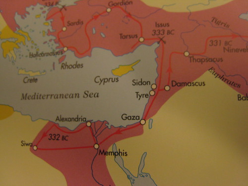
this ancient fishing village by Alexander of Macedonia, in 332 BCE, became
famous for the light house built on the island of Pharos and library.

“Alexandria was built on top of an existing, and perhaps quite important,
settlement, maybe one that was minimized in importance because we can’t see it
now,” Stanley told LiveScience. “Nothing really concrete about Rhakotis has
been discovered until now.”

Alexander the Great likely chose this area for Alexandria since it had a bay
to protect a harbor against fierce winter storms in the Mediterranean.

“There are very few places in the Egyptian Mediterranean coast where the
coastline is not smooth,” Stanley said. “This would have been the best place
to establish a harbor.”

Stanley added this bay was even noted in Homer’s epic Odyssey: “Now in the
surging sea an island lies, Pharos they call it. By it there lies a bay with a
good anchorage, from which they send the trim ships off to sea.”

This area might have been a haven throughout ancient times for the Greeks,
Minoans, Phoenicians and others. Future research could shed light on the life
of mariners at this settlement before Alexander came.

“Virtually nothing is known of the people who would have lived there,” Stanley
said.[Hidden
Egyptian City Found Beneath Alexandria
]

This is similar to how underwater archaeology
in the coast of Gujarat revealed the existence of the
remains
of an ancient city
near present day Dwaraka.

The discovery of ancient cities beneath the present day ones also reveal a great
deal about the continuity of cultures and how conservative they were.
Archaeological excavations in Mohenjo-daro reveal intense conservatism. Among
the nine strata of buildings that have been revealed, new houses that were built
over the previous ones were found to have almost the same floor plan for nearly
a millennia. This conservatism was seen even in the script which remained
unchanged even though they had contacts with other civilizations like
Mesopotamia.

Toba Survivors in Andhra Pradesh

toba

The journey of man animation on the Bradshaw foundation site shows how man reached various continents moving out of Africa starting around 150,000 years back. According to the journey, humans reached India around 85,000 years back and went to Sri Lanka and Indonesia.
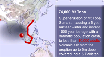
Then, around 74,000 years back, there was an eruption in Toba in Sumatra called the Youngest Toba Tuff (YTT) which resulted in an ice age and volcanic ash covering India. It is believed that the volcanic ash flung into the atmosphere blocked sunlight resulting in a nuclear winter. There was also a population reduction and according to one model, present day humans are descendants of few survivors of the Toba catastrophe.
Investigation of the Toba ash deposited in an Andhra Pradesh village called Jwalapuram in Kurnool district has revealed thatthe blast was not that catastrophic and that some of the hunter gatherers of India survived.  Stone blades and other tools  as well red ochre used in cave paintings were found both above and below the ash layer indicating that whoever lived at that time survived and there was technological continuity.

These tools were also similar to the ones used to the ones found in Africa around the same time indicating that Indians had closer affinities to African stone age traditions than European ones. It also validates the theory that humans took the route from Africa, through Arabia into India and that India was populated much before Europe. The best evidence to seal the argument would be the discovery of fossil evidence, either human or Neanderthal, but none has been found.

The Virtual Qumran

The History Channel documentary on the Lost Years of Jesus mentioned a possibility that the concept of baptism came to Jesus when he and John the Baptist lived among the Essenes  and that later the Essenes moved to Qumran in the West Bank from Jerusalem due to the fear of Romans. The documentary also suggested a theory that Jesus was a revolutionary fighting the Romans and those activities have been left out of the Bible since it would be difficult to circulate such a document while being governed by the Romans due to which there is no mention of what he did between the ages of 12 and 30.

We know that the Essenes consisting of about 75 men, moved to Qumran,  a desolate desert site, sometime between 130 and 100 B.C to escape Roman persecution. It is believed that they lived in a monastery, whose ruins are present even now, and wrote the Dead Sea Scrolls, the only surviving texts of the Hebrew Bible written before 100 AD.

For years archaeologists have argued about the ruins which indicate an assortment of buildings and spaces over a 20,000 square foot area. Now a virtual 3-D reconstruction of the site has revealed that the building was a fortress once occupied by warriors called called the Hasmoneans  and others before the Essenes converted into a monastery. The original structure was built around 160 BCE and consisted of a two-story building and four-story tower.

 In 183 BCE, in India, the last Mauryan emperor Brhadratha  was assassinated by his general Pusyamitra Sunga. By that time the empire built by Chanakya, Chandragupta Maurya and Asoka were disintegrating with Afghanistan, Gandhara, Kashmir, Punjab and Malwa all breaking away. While the Roman-Essenes fights were going on in the neighborhood of Jerusalem, the Sunga dynasty, established by Pusyamitra was ruling a large portion of India from Vidisha. (Pusyamitra’s son Agnimitra is one of the principal characters in Kalidasa’s Mālavikāgnimitram).

Around 70 CE, the monastery was destroyed by the Romans but  now you can take a virtual tour of the monastery/fortress through the following YouTube video.

See Also: Virtual Qumran Blog, Virtual Qumran Visualization Project

Ancient Rock Art in Tamil Nadu

It is not the oldest or longest, but more rock art dating back to 1500 BCE has been found in Tamil Nadu.

The paintings have been done on a rock surface that is 40 feet long and 20 feet tall. He and other experts put the date of the ancient rock paintings around 1500 B.C. These paintings include a tiger with its mouth wide open, a deer with straight horns, a porcupine, a wild boar, a peacock and elephants.

There are paintings of marching men in anthropomorphic form within a circle. Below are also men in marching form but not within a circle. There are scenes of an unidentified animal chasing another, an elephant seizing a man with its trunk with another man running after the elephant, etc.

Human figures are aplenty, showing men fighting and dancing. A rare painting has a man in profile, with a peculiar headgear. There is a glut of “mystic” designs and ancient graffiti. A leit motif is the figure of a ladder made out of bamboo poles. Such ladders are used even now to extract honey from beehives situated at heights near the tribal villages. [Ancient rock art dating back to 1500 B.C. found in Tamil Nadu]

King Herod's Tomb

According to the Gospels, Herod was the king when Jesus was born. Though there is no historical evidence for Jesus, a tomb belonging to Herod has been found in West Bank. It contains a sacrophagus believed to contain Herod’s remains. The tomb was found in Herodium, the only site which carries Herod’s name.

An ancient staircase used in a royal funeral procession led an Israeli archaeologist to solve a 2,000-year-old mystery, the location of the tomb of the Roman-anointed “King of the Jews,” Herod the Great.

The pieces of the “large unique” sarcophagus, made of Jerusalem reddish limestone and decorated with rosettes, was discovered on the northeast slope of the mesa, where archaeological excavation began in August 2006.

“Only very few similar sarcophagi are known in the country and can be found only in elaborate tombs,” he said.

It “was broken into hundreds of pieces, no doubt deliberately,” Netzer said, adding that it appeared to have been destroyed between 66 and 72 AD during the first Jewish revolt against the Romans.[Israeli
archaeologists unearth King Herod’s tomb
]

According to the legends, Moses was born at a time when the Pharaoh
had ordered all male children to be killed by drowning in the Nile. King Herod
of Jerusalem, who lived in the first century BC, in a similar fashion ordered
all male children to be killed to prevent a threat to his rule. There was a
prophecy that he would lose this throne to the newly born King of Jews and like
Kamsa, he wanted
to preempt it. Historians believe that this incident was copied from the Exodus
to show Jesus as the new Moses and it never happened.

Herod died a natural death, unlike Kamsa and  was buried in Herodium as per
the documents of historian
Josephus
Flavius
.  They were not able to find his grave, till this week.

See Also:
Herod’s
Tomb: The Hebrew University Press Conference

Longest Rock Art

The spectacular Indian rock art is not very well known both in India and outside. Though the most famous one is Bhimbetka (near Bhopal), there are other sites like Karabad,Shamla Hill and others. Now a record is being set in India, for the longest chain of ancient rock art.

The 12-km-long site, with most of its petroglyphs or pre-historic rock carvings intact, has been discovered in Mandsaur district of Malwa region, which is also home to Bhimbetka, the UNESCO world heritage site, 45 km south of Bhopal. The Rock Arts Society of India (RASI), which knew about the existence of the site for sometime, has now gone official saying the site in the Vindhyan tableland, a plateau lying north of the central part of the Vindhya range, is indeed the “longest chain of rock arts in the world”.

“Nowhere in the world has anybody come across such an extensive chain of rock arts with little interruption. What’s exciting is most petroglyphs are intact,” internationally acclaimed paleontologist and former RASI secretary G L Badam told TOI.

Earliest carvings in the chain are mostly of animals like rhino, nilgai , bear, panther, elephant, monkey, turtle and crocodile. But there are also pictures of cow, bull, buffalo, pig and horse. Experts have called the discovery of the Bhanpura rock arts as “an important milestone in the history of anthropology”. “The presence of a variety of rituals, processions and fighting scenes goes to prove the continuity of the art and early man’s culmination into community living,” said Badam. [World’s longest rock art chain in Vindhyas]


Lost & Found: Mini Continent

Mini-continent discovered

A mini-continent that was formerly joined to India has been discovered deep under the southern oceans by the world’s most powerful ice research vessel, said German scientists. They spoke as the ship, the Polarstern, docked on Saturday in its homeport of Bremerhaven, Germany, after a 19-month research voyage to Antarctica.
The ninth phase of the voyage was a study of the undersea Kerguelen Plateau, which was orphaned after the ancient continents separated, with India drifting away from Antarctica. The findings suggest that the plateau, about the size of Germany and France combined, is just the tip of a bigger piece of lost continental crust, the scientists said.
Geophysicists did seismic and magnetic surveys to explore the gap between the little-understood plateau and East Antarctica, the Alfred Wegener Institute of polar research in Bremerhaven said. “This plateau was created by a massive volcanic eruption shortly after India and Antarctica separated about 120 million years ago to form the Indian Ocean,” said geophysicist Karsten Gohl.
“For the first time, we have been able to see how the succession of volcanic deposits at the southern side of the Kerguelen Plateau, which reach right to the Antarctic continent, mostly have continental crust underneath them.
“Our findings show that a continental fragment of a size hitherto never suspected must have existed between India and the Antarctic.”

Dwaraka Update (3): The City submerged by Tsunami

One question that has often come  regarding the under water archaeology happening in Dwaraka is about age of the retrieved artifacts. When some artifacts were retrieved in 2002, Dr. Murli Manohar Joshi made the claim that a 9500 year old civilization, which pre-dated the Harappan civilization has been discovered, but some experts remained skeptical, both about the age and the use of the word “civilization”.

Under water earthquakes or volcanic eruptions can cause water to move as fast as 600 miles/hour and cause waves as tall as 100 meters  capable of destroying islands and coastal cities without any warning. It is believed that the shore temple at Mahabalipuram which survived the 2004 tsunami is one of seven temples, of which six got destroyed in previous tsunamis.

In a recent conference, it has been revealed that the debris found under water in Dwaraka are the ruins of a city dated to 2280 BCE and destroyed by a tsunami. The region around Dwaraka had suffered tectonic upheavals in 3000 BCE, 1000 BCE and 550 BCE, but since the city has been dated to 2280 BCE, it is believed that the second upheaval destroyed it.

One of the earlier complaints about the mapping and under water photography of the Dwaraka site has been addressed. The site has been scanned through high resolution underwater photography and the sea bed mapping has also been done.

Previously it was found that during the Late Harappan Phase, Bet Dwaraka had an extensive shell industry which provided artifacts to the Indus Valley Civilization. One significant find now has been a glyptic clay seal identical to ones found in Mohejo-Daro, thus confirming the contact between Indus Valley and the Gujarat coast.

See Also: Dwaraka Update (1), Dwaraka Update (2)

Harappan site in Jamnagar

One more Harappan site in Saurashtra offers a glimpse into history

The site is at Pithad village in Jodia taluka of Jamnagar district. The remains of the Harappan site have been excavated by a team from MSU.

“It is a huge wall which appears to have been constructed to protect the village. It is 270 metre in length and 90 metre in width. It is constructed on a mound, which is 2-3 metre high from the surface,’’ said Ajith Prasad, a reader with MSU, who is leading the excavation team.

“The excavation at this site began last year, and this is the second session of excavation. Earlier, small kilns to make clay utensils were found. Ovens to melt meats were also found. Besides, pieces of clay utensils, weapons made up of stones, rooms, kitchens were also found. “Our study suggests that here a Harappan civilasation existed precisely around 2300 BC. Further, the study based on excavation and its finding confirms that Harappan civilisation settlements were done with good planning,” said Prasad.

The excavation has revealed the presence of a settlement inside as well as outside the fortified wall. “The inside area was used for craft activity and residential purpose. In the area outside the wall, there settled those who were not included in the town management,’’ said Prasad.

Other Harappan Sites discovered are Rakhigarhi (Haryana), Bagasara & Rapar (Gujarat),  and Baghpat (Uttar Pradesh)

Tags: Technorati Tags: Pithad, Jamnagar, Harappa, India, Ancient History, Archaeology